


Bloom Twp. Voting District, Nobles County, Minnesota
About
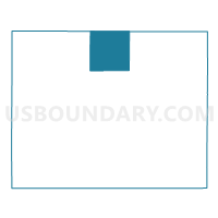
Outline

Summary
| Unique Area Identifier | 603329 |
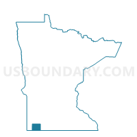
| Name | Bloom Twp. Voting District |
| County | Nobles County |
| State | Minnesota |
| Area (square miles) | 35.89 |
| Land Area (square miles) | 35.81 |
| Water Area (square miles) | 0.08 |
| % of Land Area | 99.78 |
| % of Water Area | 0.22 |
| Latitude of the Internal Point | 43.79780000 |
| Longtitude of the Internal Point | -95.74272940 |
Maps

Graphs
Select a template below for downloading or customizing gragh for Bloom Twp. Voting District, Nobles County, Minnesota


Neighbors
Neighoring Voting District (by Name) Neighboring Voting District on the Map
- Bondin Twp. Voting District, Murray County, MN
- Elk Twp. Voting District, Nobles County, MN
- Iona Twp. Voting District, Murray County, MN
- Larkin Twp. Voting District, Nobles County, MN
- Seward Twp. Voting District, Nobles County, MN
- Summit Lake Twp. Voting District, Nobles County, MN
- Wilmont Twp. Voting District, Nobles County, MN
Top 10 Neighboring County Subdivision (by Population) Neighboring County Subdivision on the Map
- Summit Lake township, Nobles County, MN (323)
- Bondin township, Murray County, MN (268)
- Elk township, Nobles County, MN (253)
- Seward township, Nobles County, MN (208)
- Larkin township, Nobles County, MN (188)
- Wilmont township, Nobles County, MN (184)
- Iona township, Murray County, MN (163)
- Bloom township, Nobles County, MN (158)
Top 10 Neighboring Unified School District (by Population) Neighboring Unified School District on the Map
- Worthington Public School District, MN (15,742)
- Fulda Public School District, MN (2,527)
- Adrian Public School District, MN (2,383)
Top 10 Neighboring State Legislative District Lower Chamber (by Population) Neighboring State Legislative District Lower Chamber on the Map
Top 10 Neighboring State Legislative District Upper Chamber (by Population) Neighboring State Legislative District Upper Chamber on the Map
Top 10 Neighboring 111th Congressional District (by Population) Neighboring 111th Congressional District on the Map
Top 10 Neighboring Census Tract (by Population) Neighboring Census Tract on the Map
- Census Tract 9002, Murray County, MN (3,246)
- Census Tract 1052, Nobles County, MN (3,165)
- Census Tract 1051, Nobles County, MN (2,889)